This map is for sale at the Map Center.
https://www.mapcenter.com/store/p/prudence-island-by-antonio-smith
Introduction
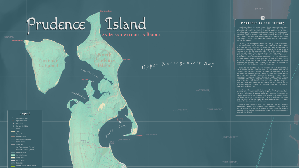
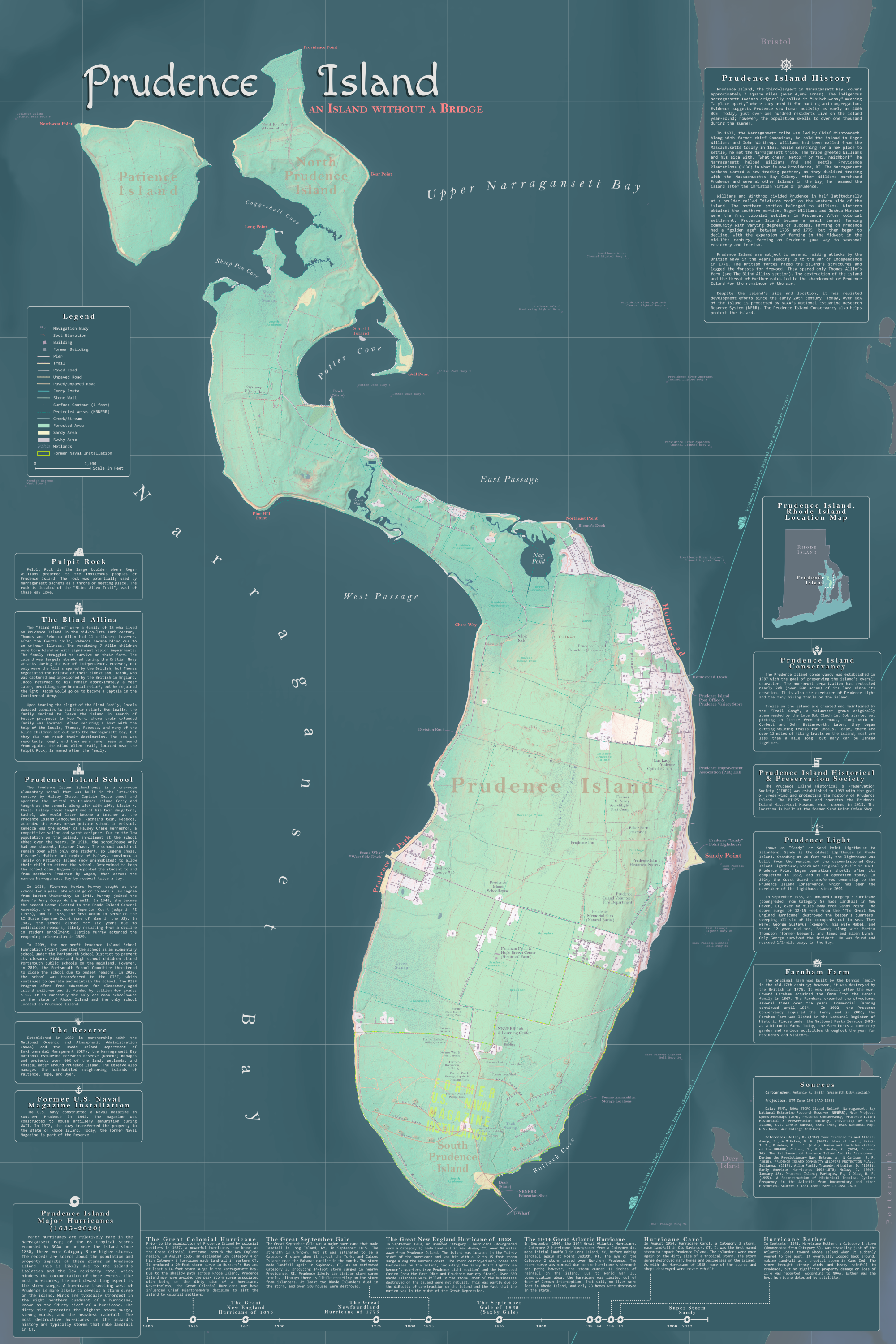
Anchored at the heart of Narragansett Bay, Prudence Island, Rhode Island, stands as the third-largest island in the region. Home to just over one hundred year-round residents, the 7-square-mile island is only accessible by ferry. In summer, the population grows to over one thousand. Despite its size and location, the island has resisted development since the early 20th century. Today, over 60% is protected by the National Estuarine Research Reserve System and the Prudence Island Conservancy.
Prudence Island Background
Prudence Island is the third-largest island in Narragansett Bay, measuring approximately seven square miles. The indigenous Narragansett tribe called it “Chibchuwesa,” meaning “a place apart,” and used it for hunting and seasonal congregation. Archaeological evidence indicates habitation as early as 4000 BCE. Today, just over one hundred residents live on the island year-round, with the population rising above a thousand during the summer.
In 1637, the Narragansett tribe was led by Chief Miantonomoh, who, along with former chief Cononicus, sold the island to Roger Williams and John Winthrop. Williams was exiled from the Massachusetts Colony in 1635. While searching for a new place to settle, Williams met the Narragansett tribe, who famously greeted him and his aide, “What cheer, Netop!” or “hi, neighbor!”. The Narragansett aided the exile in finding and settling the Providence Plantations (1636) in what is now Providence, RI. The Narragansett sachems were seeking a new trading partner, as they disliked trading with the Massachusetts Bay Colony. The sachems initially courted John Oldham, an exile of the Plymouth Colony; however, he never established a trading post. Oldman was killed by a native in 1636, possibly a tribe in alliance with the Narragansett tribe, kicking off the Pequot War. Williams convinced the Narragansett to side with the colonists, and the Pequot tribe was defeated and destroyed. After the purchase of Prudence, along with several other islands in the bay, Williams renamed the island after the Christian virtue of prudence.
Prudence Island may have belonged to the Wampanoag tribe to the east, in what is now Cape Cod. The island lies at the edge of both tribes’ territory, particularly after the relatively recent expansion of the Narragansett. Chief Miantonomoh may have courted the colonists to the island to prevent the Wampanoag Tribe from using the island. This would create a new trading partner and a buffer zone from a rival tribe.
Williams and Winthrop divided Prudence Island latitudinally at a boulder known as Division Rock, located on the western shore. The northern half went to Williams, and the southern to Winthrop. Roger Williams and Joshua Windsor were among the earliest colonial settlers, establishing a farm near Sheep Pen Cove in northern Prudence. Following colonial settlement, tenant farming was established with varying degrees of success. Some farms were abandoned following native raids, likely conducted by the Wampanoag Tribe.
Inhabitation of the island was unstable for early colonists. Many farmers departed the island during King Philip’s War (1675-76) due to the island’s isolation and vulnerability. Prudence Island was subject to several raiding attacks by the British Navy in the years leading up to the War of Independence in 1776. The British forces razed the island’s structures and logged the forests for firewood, save for Thomas Allin’s farm (see The Blind Allins). The destruction of the island and the threat of additional raids led to the abandonment of Prudence Island for the remainder of the war.
Many of the original tenant farmers never returned to the island. However, since the island’s “golden age” of farming (1735-75), the agricultural industry began to decline. With the expansion of farming in the Midwest Region in the mid-19th century, agriculture on Prudence gave way to seasonal residency and tourism. In 1875, Prudence Park was founded as a summer resort, with the Homestead resort following in 1904. Development on Prudence Island is generally linked to ferry services. With the decline in farming and a rise in tourism, much of the deforested land on the island began to recover.
Since the early 20th century, the island has resisted development efforts. Today, over 80% of the island is protected by NOAA’s National Estuarine Research Reserve System and the Prudence Island Conservancy.
Additional Map Details
1-Foot Surface Contours

South Prudence and the Former US Naval Magazine Installation

Prudence Park

An Island Without A Bridge