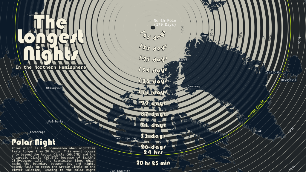
The Winter Solstice is approaching on December 21st, which means the nights will soon get shorter until the summer. Assuming you live south of the Arctic Circle, of course. For this map, I revisited one of my most popular maps from the 2025 #30DayMapChallenge for an update.
If you are like me, the worst part of winter is the darkness. I can deal with the cold for the most part, but the long nights used to get to me. I lived in Michigan for six years, and the cabin fever I experienced was almost overwhelming. It was probably a form of seasonal affective disorder. Because as the winter solstice approached, it felt like the long nights would continue to get longer with no end in sight.
Then we moved to Tennessee. My seasonal affective disorder was cured. I no longer had cabin fever by late winter. Unfortunately, we stay inside all summer because it is way too hot outside.
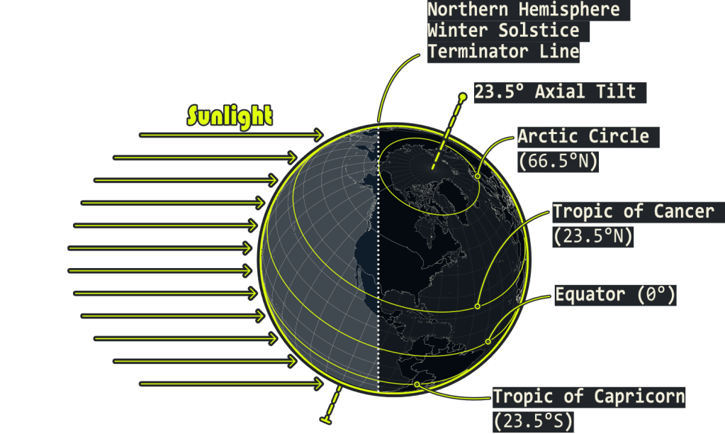
A few years later, I earned my Bachelor’s degree in Geography and learned how seasonal variations at different latitudes worked. The 23.5-degree tilt of the planet as it orbits the sun varies the amount of insolation the surface receives during the year. If the poles are perpendicular to the sun, which occurs twice a year on the equinoxes, all regions receive around 12 hours of sunlight. Insolation is weaker near the poles, due to the curvature of the Earth’s surface. Therefore, the polar regions will be limited to how warm they can get during the summer. There are other factors as well.
Old Map

The New Map! I didn’t change much other than some fine-tuning. I also added some descriptions and a global insert map.
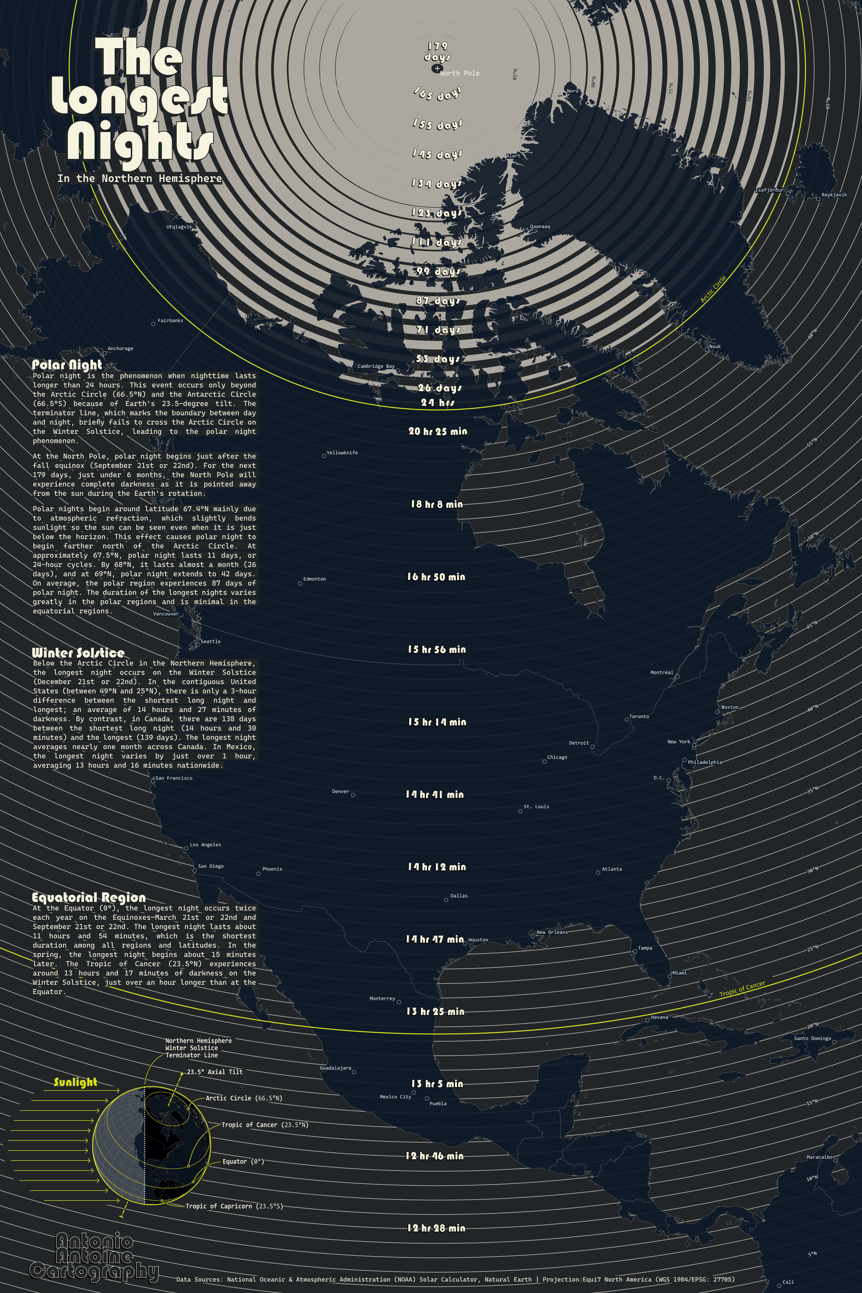
For most places, the longest night occurs on the Winter Solstice (December 21 or 22). The long night shortens to around 12 hours as we approach the Equator. However, at the Equator, the longest night happens twice, both occurring on the Equinoxes. Each lasts about 11 hours and 54 minutes.
From around the Equator to just beyond the Arctic Circle (66.5°N), the longest night doubles from 12 to 24 hours. Polar Night (over 24 hours of darkness) actually begins just beyond the Arctic Circle at 67.5°N. This phenomenon is due to the refraction of sunlight by the atmosphere. At the next tenth of a degree north latitude (67.5°N), the longest night triples to 72 hours! At 67.6°N, the longest night jumps to 11 days! By 68°N, the longest night is nearly a month long, at 26 days. Contrary to popular belief, the approximately 6-month period of darkness occurs only at the poles. Since we live on a spherical object, the inverse occurs at the Summer Solstice in June.
Map Description
The original version of this map was based on an A4 page size. This new version was rescaled to an Arch D (36×24 in) page. I added some descriptions to explain the longest nights in the Polar Night scenario, Winter Solstice, and the Equatorial Region.
Tools Used
- QGIS 3.4x
- Globe Builder Plugin
- Affinity Designer 2.x
Other
This map will be available in print form soon!