
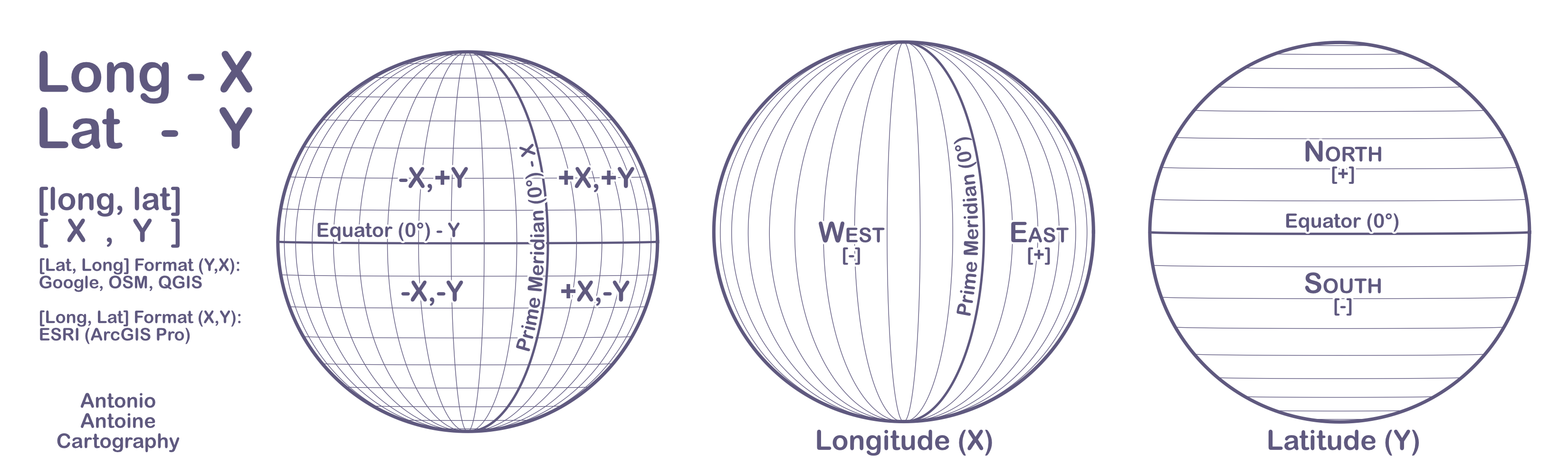
Lat Long X Y
Cliff Notes: X = Longitude / Y = Latitude
Long/Lat or Lat/Long?
Is X Lat or Long? I have tried everything to remember that Longitude is X and Latitude is Y. I have tried nicknames (Latty, Latitudey) and any correlations I could find (Lat has three letters, and Y has three points or X measures aCross). They all work for a summer, and then I am back at square one. I think part of the problem is that I usually list Long and Lat as “Lat Long” and “X Y”. Well, this inversion seeps into my subconscious, invoking the 50/50/90 rule that has plagued my life.
What is the 50/50/90 rule? In a 50/50 scenario, we guess the wrong answer 90% of the time. It’s a joke, but feels real enough to me.
At this point in my life, with a Master’s degree in GIS, I have decided to just brute force memorize “Long Lat X Y” in relative order. Plus a graphic! See below. There is a JPG version at the bottom of the post that you are free to use and share.
So why Long/Lat instead of Lat/Long? In Cartesian coordinate systems, we typically measure or read horizontally first (X) and then vertically (Y). In GIS or geography, this correlates to reading longitudinally (X) first, then latitudinally (Y). The consistency is key for me. However, if the inverse works for you (Lat/Long Y/X), then feel free to use that format.

It should be noted that almost all online maps (Google Maps, OSM) use the Lat/Long format. QGIS also uses the Lat/Long format. As far as I can tell, only ESRI uses the Long/Lat format.
Longitude (X)

Lines of Longitude run north and south, converge at the poles, and measure east and west. Lines of longitude are also called meridians, starting from the Prime Meridian (0°), measuring eastward to the antimeridian (180°). Unlike the equator, the prime meridian is arbitrary. Any meridian can serve as the prime meridian, as all meridians can split the earth into two equal parts.
Latitude (Y)

Lines of Latitude run east and west but measure north and south. Latitudes are parallel (also called parallels) and equidistant; they vary in length from the Equator (0°) to the poles (90° N/S). The distance between latitudes appears to close near the poles due to the surface leaning away from the viewer in an orthographic projection. The equator is the only line of latitude that divides the Earth into two equal hemispheres.
Other latitudes:
- Tropic of Cancer (23.5° N)
- Tropic of Capricorn (23.5° S)
- Arctic Circle (66.5° N)
- Antarctic Circle (66.5° S)
JPG Version

Hopefully this helps!