
Rhode Island is home to nearly 400 miles of coastline and just under 50 shipwrecks. While it is the smallest state by area (1,500 square miles), the “Ocean State” has the second highest coast/area ratio (1,300 feet per square mile), just behind Maryland at 1,400 feet per square mile.
This 18×24 inch map highlights Rhode Island shipwrecks from the War of Independence to the Second World War and beyond. Most shipwrecks are located in or near the Narragansett Bay.
This map is available as a print!

Notable Shipwrecks
Most wrecks were caused by pilot error in low-visibility conditions, notably fog, which is a common occurrence in Rhode Island.
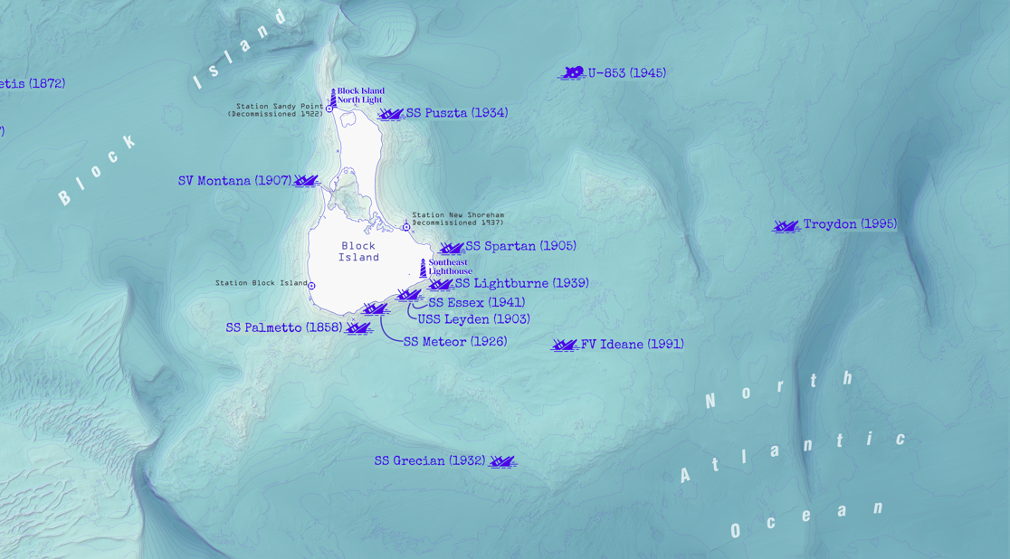
HMS Liberty (1769)

Others, such as the HMS Liberty (1769), were sunk deliberately by a mob, leading to the Boston Massacre. Some vessels were sunk during wartime, such as the SS Black Point during WWII.
SS Black Point (1945)

During World War II, the cargo ship SS Black Point was sunk southeast of Point Judith by the U-boat U-853, killing 11 crewmen. This incident kicked off the Battle of Point Judith during the final days of World War II. U-853 was sunk the next day (May 6th) by the USS Ericsson destroyer group, killing all crewmen. Germany surrendered two days later on May 8, 1945.
The Larchmont Disaster (1907)

Unfortunately, the most disastrous sinkings were due to passenger vessels colliding with other ships. These incidents resulted in the highest number of casualties as in the “Larchmont Disaster” in 1907. The SS Larchmont was a 252-foot passenger sidewheel steamship carrying approximately 200 passengers and crew from Providence, RI, to New York City (the exact number of passengers is unknown). On the night of February 11, 1907, the SV Harry Knowlton collided with the Larchmont, destroying her power lines. The ships were sailing at night during a winter storm, with low visibility.
The SV Harry Knowlton sailed for the coast as she began to take on water. It sank just off the coast, southwest of Charlestown. The seven crew members escaped to their lifeboat, and they were rescued by the crew at the nearby life-saving station. They suffered from frostbite due to the below freezing conditions and high waves from the winter storm.
The SS Larchmont faced a much worse fate. The Harry Knowlton crew was unaware that the Larchmont had sunk, and in fact, expected to receive assistance from the ship due to the damage to their ship. Search and rescue efforts did not begin until the next day, after lifeboats washed ashore on Block Island. Many passengers were asleep when the incident occurred and likely would not have reached a lifeboat in time. More lifeboats were found at sea, carrying survivors and those to succumed to the conditions. The hurricane deck was found floating as a makeshift raft, carrying 15 passengers; 7 had already died and frozen. Nearly 200 passengers and crew died in the incident; however, the exact number is unknown.
HMS Endeavour (1778)

Quite possibly the most famous shipwreck in Rhode Island is the HMS Endeavour. The Endeavour was one of the ships used by Captain James Cook to sail around the world from 1761 to 1771. It was decommissioned a few years later and renamed the Lord Sandwich. She was used to transport troops from Britain to the United States during the War of Independence. It was scuttled in 1778 between Rose Island and the Port of Newport as part of a British blockade of Newport Harbor. The connection between Lord Sandwich and the HMS Endeavour was made in 2025 by the research teams at RIMAP and ANMM.
Other Shipwrecks
There is one shipwreck just outside the area of interest. MT Norness was sunk in 1942 by a German U-boat during WWII.

Rhode Island/New England Shipwreck Resources
If you are interested in exploring other shipwrecks in the New England region, there are a couple of resources out there: